Weather Warning for Andhra Pradesh on 8th May 2020

Weather Forecast for Andhra Pradesh on 8th May 2020

Thundershowers possible in some areas of Srikakulam and Viziangaram districts while Hot Weather conditions will prevail in Rayalaseema

1/4/2016-Weather forecast for south india:

As expected earlier there has been a decrease in the amount of heat inside the sub-continent. But some places of andhra pradesh and telangana showed some temperatures above 45 degrees at isolated places.

The temperature will decrease for next two days and will again shoot up to a maximum .


Weather Extremes:

Highest Temperature: Nandhyal(Kurnool district): 46.2 degrees
Highest Rainfall: Kalakadu(Tirunelveli district): 2.5mm
Lowest Temperature: Kodaikkanal(9.5 degrees)

Trend:

The trend is likely to continue for the next two days and the temperatures will shoot up to maximum. The places of south-interior karnataka, kerala will get good rains after 9th april.

30/3/2016


28-March-2016

Rain lashes at isolated places of South Tamilnadu:

As predicted by me earlier, rainfall occured over isolated places of South Tamilnadu and ad adjoining places of Srilankan land mass. The same trend is likely to get continued for the next 2 days. Rain will spread into the interior areas of tirunelveli district and parts of south kerala. It is also noticed that the easterlies are strong and they are providing good amounts of moisture to south tamilnadu and srilankan landmass. 

Temperature trend over rest of south india:

Rain requires moisture,thermodynamic support, shear stress, cape, lifting index and some factors like Convergence at lower levels.
Moisture is absent at many places of india except the south tamilnadu coast and adjoining kerala. 
Andhra, Telangana, Kerala, North Tamilnadu, Karnataka will get relatively hot weather. It is also noticed that the amount of heat decreased over many places and all the places returning to normal trend.
Hottest temperature recorded at kadapa district with 45.2 degrees celcius.

When summer rains start over interior Tamilnadu and kerala??

The natural thunderstorm season will start over kerala and interior Tamilnadu around second week of april. I am expecting a dipped north-westerlies to make a wind confluence at 850 hpa levels by April 9th.

Heavenly places during may in South india(Cities):

Many places of kerala will get summer showers(Mango-Showers) during april, when most parts of india reels under hot conditions. They generally bring cooler weather and the moisture at various levels even spread into interior Tamilnadu and South interior karnataka.
Places like Madurai, Coimbatore, Salem, Dharmapuri,  Bangalore, Kozhikode, Trivendrum, Kollam, Punalur, Thissur, Kottayam etc. Gets summer showers.

But cities like chennai, hyderabad, nizamabad, nellore, tiruchi, belgaum, bellary, gulbarga will get good heat and occasional Thunderstorms.

By 
Sai praneeth

28/03/2016 weather forecast

28/3/2016 Forecast-

Light Rain to Occur Over SriLanka and South Tamilnadu:

Lankan story:

  • Light to moderate rain likely to occur over Srilanka and south-coastal Tamilnadu for 2-3 days starting from tomorrow's night. The easterlies blowing in bay of bengal has gain gained strength, particularly over Srilanka and aiding lots of moisture into the island. The high pressure has moved a bit towards Burma and the easterly jet rushing with good amounts of moisture into Srilanka.
  •   The trough of low at mean sea level over central parts of south Bay of Bengal and neighbourhood persists. It will move and reach srilankan land mass by tomorrow night and by 29/3/2016 it will spread into South-coastal Tamilnadu. Places like Tuticorin, Ramanathapuram, Kanyakumari, Nagercoil, Tirunelveli-western ghat areas(Tenkasi, Coutrallam, Ambasamudram) have a wide chances of getting rains on 29,30th of march.

What About Rest places in South india?

  • By reading the above lines about lanka, many will ask what about rest of the places in south-india??
  • I say almost all places of south india likely to remain dry and some places(mainly kurnool district) will become heated up to temperatures upto 45 degrees.
  • The circulation over madhya maharastra and madhya pradesh seems filled with dry and hot air instead of moist air. So mostly all places will get dry weather and places along the east coast will maintain maximum upto 36 degrees.
  • Inspite of the dry weather, i can see some moisture persisting over the places of Araku hills of vishakapatnam district. Tomorrow, expected showers (10-20mm) might occur over some places of araku hills.

Extremes of south india:

Highest Temperature: Thallaprodattur, Kadapa district, Andhra Pradesh (45.8 degrees celcius)
Lowest Temperature:  Udhagamandalam(Ooty), Nilgiri District, Tamilnadu (7.1 degrees celcius)
Highest Rainfall:  Munchigiputtu, Vishakapatnam district, Andhra Pradesh (19mm)
Highest Humidity: Many places along east coast of southindia got 90% Relative Humidity.

Pic1: Special concentration on srilanka and south-coastal Tamil Nadu

 Pic2: Distribution of Temperature in Andhra


27-3-2016 Weather Forecast For South India:

PAST OBSERVATIONS:

For the past 5 days most parts of the peninsular India has faced dry weather. Some places went past 45 degrees, mainly in the semi-arid regions of Andhra Pradesh. Many coastal areas along the east coast got temperatures between 33-36 degrees, due to wing blowing from east side. The trend is going to continue. The interior areas of Tamilnadu, Telangana, Karnataka and Andhra Pradesh got many 40 degree plus temperatures. Kurnool district is mainly affected by 45 degree heat at isolated places.

Any relief expected for tomorrow??

  • No chance for getting any sort of relief. Because of the presence of High pressure area in Bay of Bengal, the air getting more drier over the interiors, thus leading to good heat. "Tomorrow will almost be same as today"----Remember my quote.
  • Nights will be warmer with 22-26 degrees over vast areas of south india over plains.
  • Hilly areas like Nilgiris, Araku, Tirumala, Agumbe, Dharmasthala, Kodaikanal, Yercaud, Elagiri might get lower minimum and maximum temperatures. As it is sunday plan yourself for any weekend outing.
  • Places along North-coastal Tamilnadu, likely to get 34 degrees centigrade temperature under the influence of moderate easterlies blowing from sea to land.

Special forecast for India vs Australia Match:

Partly cloudy skies expected due to the ongoing western disturbance over himalayas. Ideal conditions for match. Pitch is maintained dry and necessarily provide good spin for spinners. Also pitch good for batsman who bats first tomorrow.

As the night proceeds, the second innings may get some wet outfield due to dew. So my opinion is to win the toss and bat first, to put good runs on the board.

THANK YOU

GOOD NIGHT


Forecast for next week:


April-May outlook

APRIL MAY FORECAST:

Lets think out of the box...(for April May forecast to south india)
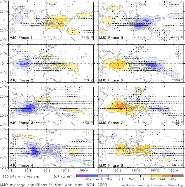
Weather of south india----New concept on MJO(Madden Julian Oscillation) and effect of it on vorticity:
We should take major factors like:
1)ENSO(Elnino-southern Oscillation)
2)MJO(Madden Julian Oscillation)
3)Kelvin/Rossiby Waves
4)Shear and TCHP(Tropical Cyclone Heat potential)
ENSO forecast for april and may:
ENSO will mainting its falling trend, but may lie in the positive end. Hence the Reverse-Walker circulation will tend to reduce the probability of tropical cyclone formation.
MJO impact during april and may:
By second week-end of may, the MJO goes to Phase-3. This will maintain a good Sea surface temperatures and superimposes during leading tip period. Thus it will tend to increase the probability of tropical cyclone during may.
Kelvin/Rossiby Waves during april/may:
These waves will give energy to the Tropical cyclone, by a constant process called isothermal process (dQ=0). This will aid to the growth of Tropical cyclones and will effect the moment. Trapped up Kelvin waves may bring huge amounts of energy to cyclonegenisis.
Shear and TCHP:
Shear depends on the wind which creates opposite nature to the formation of Tropical cyclone. Whenever a Vertical wind shear occurs, the cyclone gets affected and sheared off(Teared). Thus some of the global cyclones dissipate in open waters. It changes Time to Time.
This occurs due to the trade wind motion at mid-upper levels of the atmosphere
Heat potential depends on the amount of net Heat available, so that the cyclone uses it and grows big. It depends on the Sea-surface Temperatures and trade-wind.
Overall inference:
I am expecting a trough to develop around second-week of may, mainly due to MJO interference and available SST's. The Computerised model for long-range forecast "CFS" predicted the same and some experts expecting a low pressure to move towards andhra coast. It naturally happens for once in 5-10 years. Let's see...
Weather of south india....always with you.....
pic 1: ENSO status
pic 2: MJO status
pic 3: map of historical summer cyclones and their motion


Pic 1:
Pic 2:

Pic 3:

Hot Weather Prevails over Many Parts of South India:


NEWS:

After a bountiful North-east Monsoon, over the parts of Tamilnadu and cool winter over entire south-India, Now its the time for much awaiting season of sweating namely Summer season.

Sun has been tracking up and trespassed the equator five days back. The Dry air over the interior parts of the country, making up the hot conditions and several places of Andhra recording more than 45 degrees, that too during march.

WEATHER for "TODAY":

Parts of Rayalaseema(Chittoor, Kadapa, Kurnool, Anantapur), Coastal Andhra pradesh(Nellore, Prakasham, Guntur, Krishna), North-interior Karnataka(Belgaum, Bellary, Gulbarga, Hubli) and some parts of interior Tamilnadu(Krishnagiri, Vellore, Kancheepuram, Salem, Dharmapuri, Madurai, Sivaganga, Namakkal, Karur) likely to get temperatures between 39-45 degrees.

Tamilnadu----Moderate Heat(38-41 degrees) possible
Karnataka---Moderate Heat(34-41 degrees) possible
Andhra Pradesh-----High heat(40-46 degrees) possible
Kerala----Less Heat(32-36 degrees) possible
Telangana-----Good heat(40-43 degrees) possible

Any Chance for rain/showers??

-->>Parts of Kerala and south-coastal Karnataka likely to get some showers by today afternoon/evening...
-->>There is a sharp dip in the streamline wind flow over the parts of South-east Arabian Sea, which may aid some moisture to kerala.
-->>The flow of Moisture from kerala to Tamilnadu might bring down the Day temperatures by 1-2 degrees. Inspite of that relief during daytime, the nights will be uncomfortable.(Clouds obstruct the Heat to escape from the earth, thus increasing heat budget).

PICTURES ATTACHED:

PIC 1: Summary of yesterday temperatures over andhra
PIC2: Summary of yesterday temperatures over Telangana
PIC3: Forecast map by "WEATHER OF SOUTH INDIA"


tomorrow weather


BLAZING HEAT CONDITIONS OVER THE PENINSULAR INDIA:

As we see the insat picture, we can see nil convection over south india and parts of srilanka. The temperature changing adiabatically in many parts of south india. Most parts seems experiencing May heat and the conditions are likely to continue for the next 3-4 days.

After 28 march there might be some relief, with some  rains over kerala. Slowly the moist molecules will spread over some parts of tamilnadu.

The Line of Wind discontinuity is likely to well set over interiors by second week of april.

If an Upper air circulation forms over the arabian sea and an High-pressure anti-cyclone forms over bay of bengal, there will be an interaction of winds from either side and thus forms a wind confluence. It often brings some thundershowers over interior parts of south india.

We can see a rapid convergence over west coast of sumatra and it will move westwards and cause rains in open waters of indian ocean and pats of  south srilanka.
By sai praneeth

Hot Weather bakes Rayalaseema:

I am a resident of tirupati and the place is located in rayalaseema. Morning it was a bit pleasant and when the clock shooted 9am, Heat builded up, with patchy clouds in the sky, I felt more and more heat being added. When I checked my Temperature sensor afternoon, it looked so hot with temperature about 41 degrees.
Then I went through the temperature data for south india.

Areas with 40C temperature:

The Areas which got above 40C are:

1)Chittoor district(Central part)
2)Kurnool district(Many places)
3)Anantapur district
4)Krishna district
5)Guntur district
6)Adilabad district
7)Khammam district
8)Mahabubnagar district
9)Nizamabad district
10)Belgaum district
11)Bellary district
12)Hubli district
13)Devenagere district

Places with 35-39:

The areas with Moderate heat are:
1)Vellore district
2)Tiruvannamalai district
3)West parts of Kancheepuram district
4)Madurai district
5)Kozhikode district
6)Kannur district
7)Salem district
8)Parts of nellore district
9)Parts of Kadapa district
10)Palakkad district
11)Tiruppur district
12)Coimbatore district
13)Theni d

Parts with Humid weather:

Most places in east coast close to Bay of Bengal and places in south, south interior karnataka are relatively cooler compared to parts of south india.

Tomorrow trend:

The same type of weather with increased discomfort likely to prevail for next 3-5 days. After that we can see some relief, only if a trough of low or a circulation forms over arabian sea and a wind confluence happens in the interiors.
#By Sai Praneeth
(Student at GCT coimbatore)

Hot Weather prevails Over Rayalaseema:

Analysis:

Generally, the weather turns hot during the month of  april first week. But surprisingly, we can see many places recording good heat in mid-March itself .

Reason Behind the story:

Many scientists across the globe believe that Elnino is the main reason to bring abnormalities in terms of  temperatures across the globe.
When the east pacific becomes hot, in response to the change, the seas bay of bengal and arabian becomes slight warm and this will increase the land a bit high. But the heat mainly depends on relative dryness in the atmosphere.

At present conditions:

We have a High pressure system over the central bay of bengal, feeding dryness to the south india and no other important circulations in arabian sea, to bring good rains in interiors.
If the time goes to mid may, the upper air circulation brings a relative cooler weather, to kerala and parts of interior karnataka, interior andhra and parts of Interior tamilnadu.
I am expecting the thunderstorm season to start from april second week.
Those thunderstorms are associated with line of wind-discontinuity and often bring hail storms.
Now, places over:
1)Interior telangana
2)Western Telangana
3)Chittoor, Kurnool districts
4)Anantapur district
5)Krishna district
Getting 40 degree plus temperatures.

Until monsoon onset, the temperatures domination will prevail. Inspite of heavy temperatures, the LWD provides isolated thunderstorms in many places of interior andhra.
#Weather forecast by Sai praneeth.
Analysis:
Dry conditions with blazing heat prevailing over several parts of andhra and telangana..
My Temperature instrument using DHT 111 sensor....showing 40.6 degrees in the LCD pad....
Mainly
Kurnool
Anantapur
Tirupati
Vijayawada
Nalgonda
Nizamabad
Hyderabad
Adilabad.....
=======================
Any rains in south india???
Kerala will get rain...districts like kottayam, kollam will get evening showers close to western ghats...
=======================
Heat budget in south india??
Coastal andhra and tamilnadu...will get benefited by warm and moist easterlies....interior south india especially Andhra and telangana will reel from "Pre-Summer heat"....dont get surprised to see 43, 44 degrees in some places.
Interior Tamilnadu will post 39-39 drgrees and coastal karnataka will be moderately hot with 36 degrees