Weather Warning for Andhra Pradesh on 8th May 2020

Weather Forecast for Andhra Pradesh on 8th May 2020

Thundershowers possible in some areas of Srikakulam and Viziangaram districts while Hot Weather conditions will prevail in Rayalaseema

Heavy Monsoon on Cards

Chase For Intense-Monsoon starts-Conditions Gearing up

                                                                                                  -By Sai praneeth

The South-Indian wait??

For the past 2 years, there was a drought-like condition in many parts of country. Inspit of very-heavy rainfall over coastal Tamilnadu and South-coastal Andhra pradesh, drought prevailed over rest of south-india. During 2014-elnino like conditions prevailed and the monsoon systems didn't materialize over india. 
We have seen cyclone Komen over Sunderbans last year, which caused a good rainfall in july. But monsoon failed to make its promise during august and September.
 

2014-Elnino-like conditions
2015-Elnino conditions
During 2014,2015 there were severe conditions, which didn't supplied enough energy to the indian ocean, to trigger an intense monsoonal system.

Hud-Hud Matter??

Cyclone Hud-hud was an exceptional case, it evolved due to the superimposition of rossiby wave and MJO pulse. The MJO and Rossiby wave are the energy banks which containes heat in trapped form and propogates from one place to another. Rossiby travels from east to west and MJO travels from west to east. Some times they meet a point and cause a heavy system irrespective of elnino/lanina. 

This Time Monsoon Hit/Miss???

To see this, we have to take main factors like-

ENSO-(ELNINO SOUTHERN OSCILLATION)

Its the matter of pacific and the latent heat stored in the pacific ocean constitutes the changes in the walker circulation. The walker circulation is the sole responsible of seasonal variations of climate and weather. For the sake of brevity, the NOAA divided pacific into 4 divisions. (Nino 1+2,3,3.4,4)
elnino-conditions
       Lanina-conditions

Latest conditions:

Nino(1+2)
                            
Nino-3-

                             
Nino-3.4-

                             
Nino-4-


Inference-

So, by the end of august, there will be lanina like conditions and the amplitude of south-west monsoonal rainfall concentrates form second-week of august  to the end of september. I am expecting a post-monsoon low-pressure to touch the shores of andhra pradesh around october 1st week, as per latest CFS trend.

july- Average rainfall expected


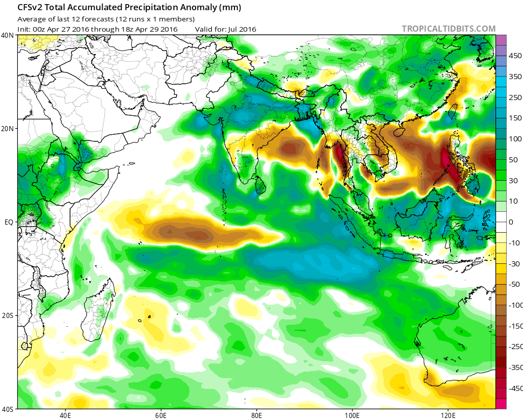
August-Above Normal rainfall expected


September-Above Normal rainfall expected


Madden Julian Oscillation-

Madden julain oscillation is a main constituent future of Rainfall pattern over India. Even in a massive elnino year, there will be some rains over india which is a consequence of Madden julian oscillation. I say it as a gift for monsoonal countries like India, Australia. During Lanina years, more latent heat is transferred to indian ocean and when MJO superimposes with the Sea surface temperatures(Latent heat).
\


It works on the principle of law of conservation of energy. "Energy can neither be created nor be destroyed but it can be changed from one form to another form". Over a period of 30-90 days, it suppresses the rainfall for some period and gives heavy rainfall or even monsoon systems over a period of time. It will dissipate, when it touches the central portion of pacific. Again, the energy is gathered in the form of latent heat over africa and the pulse with trapped energy, propogates east-wards.

Latest-Conditions-


Inference--

Recently MJO pulse became zero in magnitude and negligible Gain-margin. Now again, the energy is gathering near the east coast of somalia and the amplitude of MJO likely to increase by june.

Quasi-Bennial Oscillation-

Its the upper air directional effect. It influences the Monsoonal flow and the strength of monsoon currents. The clouds develop well if the QBO resultant wind direction and Monsoonal direction are same.


INFERENCE-

It is seen that the Monsoon will be good, if the QBO vector points to westwards, supporting the monsoonal flow at lower-levels. QBO vector is taken at 30-70hPa levels from Base ground (1133hPa).

Latest Observation-(Fight of Mean surface level pressure with a Low in indian ocean)


INFERENCE-

Due to a low persisting over southern indian ocean, the cross equatorial currents are unable to set. The low is expected to clear off by 2-3 days and conditions of Monsoon will be back to normal.

Chennai boltzz

 THE SPARKLING CHENNAI THUNDERSTORM SEASON (JULY-OCTOBER)

"THOR IN CHENNAI"

PRIME CONTRIBUTORS:

B.SAI PRANEETH
CHANDRA MOULI
SAI KRISHNA
PRADEEP JOHN
SANJANA KUMAR

STORY>>>

Chennai is one of the largest city in south India, which receives rainfall from both the Monsoons. In which the rainfall during North-east Monsoon(October-December) is predominant. During the winter season, the city gets dried up and gets hot while in summer. The sea sometimes regulates the temperature, by setting up the sea-breeze. When monsoon sets up in Kerala, the real action begins. The amount of  convective energy is added by the heat during summer. Depending on monsoonal rainfall over kerala and karnataka coasts, the moisture induces gradually into the layers of atmosphere over Interior Tamilnadu and Karnataka.

GENERAL CRITERIA OF THUNDER-CLOUD DEVELOPMENT-


Mouli, my friend says that the clouds start developing around 10 am with the available moisture and heat. They achieve the mature stage by 3pm or some times 8pm also. The time for which the Thunderstorm stays in the mature stage is called 'Mature time'. If the thunderstorm lasts more in mature time, the rainfall will be heavy.

Did Ariyalur got 30cms on a typical south-west monsoon day in 2015??

Yes, the ariyalur Town got a heavy rainfall in the afternoon hours on a typical South-west Monsoon day. The cloud band developed its momentum and stayed in the matured stage for a very long time. So this shows that the amount of "Mature-tme' increases, the rainfall increases a lot.
It depends on--
1)Avaliable Heat at the surface level
2)Moisture
3)Convective-available Potential energy(Supplied by Madden julian oscillation)
4)Some influences due to a trough of low/Upper air circulation nearby 

                     
                                                  (Floods in ariyalur)

NOTE:
The parameters listed above, will not be available all the time. They are the time varying quantities and requires more and more energy.


(Some times troughs at lower-level causes convergence and aids for thunderstorm development)

THE PROCESS OF THUNDERSTORM DEVELOPMENT :

As per the chennai standards (data collected by pradeep john), the official thunderstorm season of chennai is generally packed between july 2nd week to october 2nd week. In 2011, there was a great lanina conditions in pacific and led to effective transfer of energy from sea to land. There was a continuous formation of stroms in the interior Tamilnadu and effectively paved a way to heavy rainfall over chennai and its suburbs. 

main factors:
1) Surface Heat /upper air circulation present nearby to chennai
2)Moisture flow from Kerala/Karnataka coast
3)Timely onset of sea breeze to provide an up thrust to clouds

Storm Tracking- 

                                           Pics location-Ambattur, Chennai

STEP-1: popups with small thundershowers ping up around eastern-ghats areas of yercaud, kollimalai, jawadhu hills or some time in plains itself, where lower-convergence is predominant.


STEP-2: The small storms will develop its size with the help of heat and moisture available in the atmosphere at various levels using a constant-heat process called isothermal/diabatic process


STEP-3: The storms try to move towards the area of convergence


Note: On october 10, 2015 the region of convergence lied close to east of chennai. Hence storm converged to the east of chennai, while the chennai missed good rains. Moreover, most of the rains fell in sea.

Step-3: Storm tries to reach mature stage and further development is hindered

Step-4: Storm reaches saturation and dissipates finally and spreads in its area
 (occurs when the convergence in lower levels is less than the divergence at upper levels)

Responsive rainfall analysis:

When ever the monsoon sets over west coast, the conditions in the interior areas of Tamilnadu, Karnataka and Andhra pradesh changes a lot.
Clouds start developing near the eastern ghats and the instability develops as the day progresses towards evening. If the amount of instability increases, the clouds are lifted to a greater heights and it causes intense downpour.
"It is believed that the period between the most intense spell of monsoon and the break of monsoon over west coast, causes the more transfer of moisture to inland and cause the intense thunderstorms".
                           (Thunderstorm over chennai, taken from chepauk)
                  (Thunderstorm over Tirupati, taken from MR Palli, Tirupati-west)

SCIENCE BEHIND THE THUNDERSTROMS:


Sea breeze amplifies the convergence around the storm, by pulling the moisture upwards and creates instability. The instability tries to convert the potential energy in the form of heat and supply it to clouds. The cloud starts to develop and goes upwards. When the cloud goes upwards, the lower-level cumulus clouds gathers at the bottom of the gigantic cloud, which is moving upwards. Then after some time, the gathered cumulus clouds at the bottom joins with the gigantic cloud and results in heavy cloud called cumulonimbus or Nimbostratus depending on the amount of instability and moisture content.


There are four types of thunderstorms: single-cell, multicell cluster, multicell lines, and supercells. Supercell thunderstorms are the strongest and the most associated with severe weather phenomena. Mesoscale convective systems formed by favorable vertical wind shear within the tropics and subtropics are responsible for the development of hurricanesDry thunderstorms, with no precipitation, can cause the outbreak of wildfires with the heat generated from the cloud-to-ground lightning that accompanies them. 

Expected rainfall over South india....THIS SOUTH-WEST MONSOON:


Being a mild-lanina year, the rainfall is expected to be above normal over many parts of india. Mainly kerala and karnataka will get some heavy spells starting from june. Chances for a cyclone formation over Arabian sea is predominant now. Let's see for the further updates


Thanks
WEATHER OF SOUTH INDIA
(Sai praneeth)