Heavy to Very Heavy Rains Likely over South Tamilnadu and Adjoining Kaveri Delta- (Mysterious Depression 91B)
The Tropical depression INVEST-91B is about to enter the Gulf of Mannar and likely to concentrate into deep depression and cross the coast of Tamilnadu close to Pamban. After crossing the coast, the system likely to move northwards and about to cause heavy rain over North Tamilnadu from Tomorrow morning. Today, rainfall will be heavy to very heavy over South Tamilnadu districts. Flood warning has been issued to Kanyakumari, Tirunelveli, Tuticorin districts by Weather of South India yesterday.
LATEST CONVECTION AROUND THE DEPRESSION
CURRENT LOCATION OF DEPRESSION
PATH ASSOCIATED WITH THE TROPICAL DEPRESSION-
As said above, the depression is likely to enter Gulf of Mannar and hit the south Tamilnadu Coast and travel North-west for some time and then go straightly to North, says GFS . Heavy to very Heavy rainfall will affect the parts of coastal Tamilnadu particularly South Tamilnadu coast. The cloud band will first start to build over South quadrant and then it will move to north quadrant and cause on and off heavy rains.
DAY-1-FORECAST-16/05/2016
DAY-2-FORECAST-17/05/2016
DAY-3-FORECAST-18/05/2016
Whether it rain or not in chennai and south coastal andhra-
The tropical depression likely to move North-west for some time and then move northwards and it will have good heat support an less shear to make up good rainbands over Tamilnadu coast.
I am expecting chennai to get a rainfall between 10cm and 20cms. While tirupati will get some good rainfall from the system.
Photography-from nagapattinam (rain lashing at present)
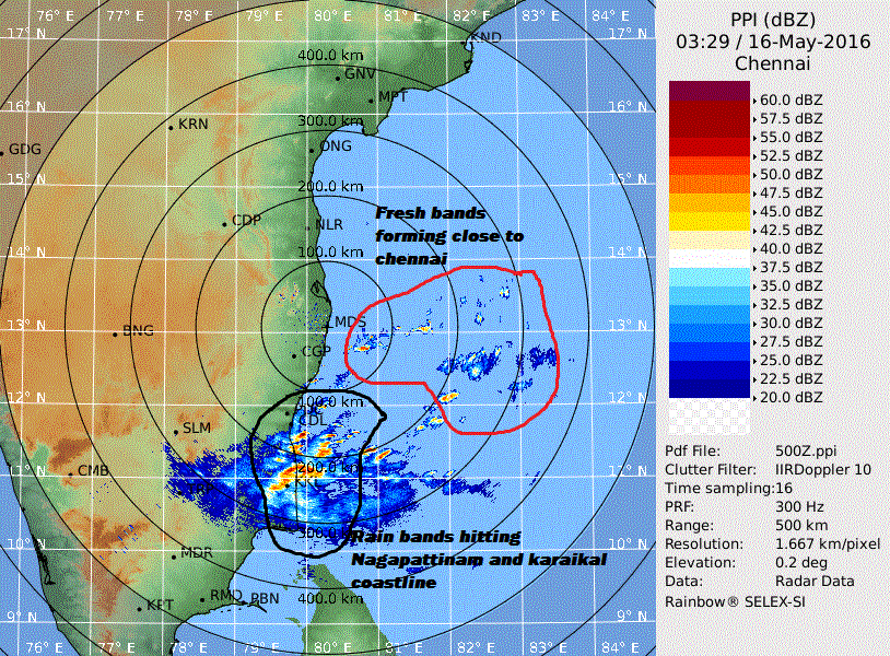
(DWR-RADAR)
RAIN LASHING NAGAPATTINAM COASTLINE
B.SAI PRANEETH
(WEATHER OF SOUTH INDIA)


