1)ENSO(Elnino-southern Oscillation)
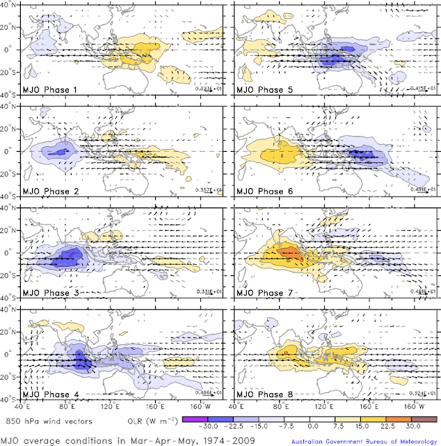
2)MJO(Madden Julian Oscillation)
3)Kelvin/Rossiby Waves
4)Shear and TCHP(Tropical Cyclone Heat potential)
ENSO forecast for april and may:
ENSO will mainting its falling trend, but may lie in the positive end. Hence the Reverse-Walker circulation will tend to reduce the probability of tropical cyclone formation.
MJO impact during april and may:
By second week-end of may, the MJO goes to Phase-3. This will maintain a good Sea surface temperatures and superimposes during leading tip period. Thus it will tend to increase the probability of tropical cyclone during may.
Kelvin/Rossiby Waves during april/may:
These waves will give energy to the Tropical cyclone, by a constant process called isothermal process (dQ=0). This will aid to the growth of Tropical cyclones and will effect the moment. Trapped up Kelvin waves may bring huge amounts of energy to cyclonegenisis.
Shear and TCHP:
Shear depends on the wind which creates opposite nature to the formation of Tropical cyclone. Whenever a Vertical wind shear occurs, the cyclone gets affected and sheared off(Teared). Thus some of the global cyclones dissipate in open waters. It changes Time to Time.
This occurs due to the trade wind motion at mid-upper levels of the atmosphere
Heat potential depends on the amount of net Heat available, so that the cyclone uses it and grows big. It depends on the Sea-surface Temperatures and trade-wind.
Overall inference:
I am expecting a trough to develop around second-week of may, mainly due to MJO interference and available SST's. The Computerised model for long-range forecast "CFS" predicted the same and some experts expecting a low pressure to move towards andhra coast. It naturally happens for once in 5-10 years. Let's see...
Weather of south india....always with you.....
pic 1: ENSO status
pic 2: MJO status
pic 3: map of historical summer cyclones and their motion
Pic 1:
Pic 2:
 |
Pic 3:
 |


