Monsoon Forecast 2020 with April conditions
Its been more than 6 months i last blogged regarding the rainfall. Normally, its my habit to blog weather when it rains. Monsoon, widely called as 'Mausam' (Season of Rains) is a transitional climatic pattern from Summer to Winter. It is the cause of Large-scale Sea Breeze blowing from Sea to Land due to Thermal contrast between Sea and Land.
Monsoon winds can be classified into -
- Arabian Sea Arm - The Monsoon, as a wind starts its journey from South of Madagascar, travels along the Indian Ocean as a weak and dry wind, then reaching Western Arabian Sea, picking up moisture and strength, penetrating through the Western Ghats of India, then through Peninsular India and finally directed to Thermal Low of Rajasthan.
- Bay of Bengal Arm - The Monsoon in this case also, as a wind starts its journey from South of Madagascar, travels along the Indian Ocean as a weak and dry wind, then reaching Sri Lanka and Central Bay of Bengal picking up moisture and strength, moving into Andaman and Nicobars, Bangladesh, Burma and of course North-east India.
- Meeting Point - The above two arms meet at the Monsoon Zone running along the Central India, where the monsoon activity is the highest. The Meeting point has embedded Low pressures (Monsoon Low's) and they normally pass through the Monsoon Zone.
Monsoon Zone and its vagaries -

Fig-1: Monsoon Zone of India. Source: IITM, Pune.
As shown in Fig-1, the marked (With bold line) region acts as Monsoon Zone. If you can notice the colors (Green one's), the zone has got a distinct precipitation characteristics and this precipitation rates decrease as we move North-west towards Rajasthan. The following states come under Monsoon Zone (Wet/Rainy):
- Odisha
- West bengal
- Chattisgarh
- Jharkand
- Madhya Pradesh
- Bihar
- Uttar Pradesh
- Extreme North of Telangana
- Nagpur/Wardha region of Maharastra
- Haryana
- Rajasthan
- Gujarat
- Interior Maharastra (Vidarbha and North-eastern Marathwada)

Fig-2: Monsoon depression in Monsoon Zone right over Jharkhand
As the Monsoon depression move along the Monsoon Zone, it will create good curved-cloud banding around its center, while pulling the winds from Arabian Sea. These winds are forced to raise by the Western Ghats and thus creating bulk amount of Rainfall. Even the Monsoon depressions drag some winds into Bangladesh/Burma during its course in the Monsoon Zone. The rains in Bangladesh/Burma are purely due to some moisture action as the winds pass through heated up Bay of Bengal. Monsoon depressions/Lows are just a catalyst (Booster) for Annual Monsoon rainfall in India. There are years where there are no Monsoon depressions, but the Annual Monsoon rainfall ended with Above Normal/Depressions. For instance we can take 2010 into consideration, where there are no Monsoon depressions, but it was an year with good rainfall. Apart from Monsoon depressions, there are several other factors like movement of Monsoon trough triggering Active/Break spells across the country, Madden Julian Oscillation etc.., that strengthens and weakens the rains all through the country.
Onset of Monsoon-
Starting from 1st Week of May, the Monsoon talk starts. Monsoon starts its setting journey first by entering into Andaman and Nicobar Islands by May 20th, then slowly progressing towards the Indian Mainland. However the actual Onset dates are deviated from Normal Onset days, when IMD Monsoon criterion is not met. Such things cause loss of hopes within the farming community and there is a myth that a delayed monsoon is destined to fail.
IMD Criterion of Monsoon Onset-
a) Rainfall
If after 10th May, 60% of the available 14 stations enlisted*, viz. Minicoy, Amini, Thiruvananthapuram, Punalur, Kollam, Allapuzha, Kottayam, Kochi, Thrissur, Kozhikode, Thalassery, Kannur, Kudulu and Mangalore report rainfall of 2.5 mm or more for two consecutive days, the onset over Kerala be declared on the 2nd day, provided the following criteria are also in concurrence.
b) Wind field
Depth of westerlies should be maintained upto 600 hPa, in the box equator to Lat. 10ºN and Long. 55ºE to 80ºE. The zonal wind speed over the area bounded by Lat. 5-10ºN, Long. 70-80ºE should be of the order of 15 – 20 Kts. at 925 hPa. The source of data can be RSMC wind analysis/satellite derived winds.
c) Outgoing Longwave Radiation (OLR)
INSAT derived OLR value should be below 200 wm-2 in the box confined by Lat. 5-10ºN and Long. 70-75ºE.
Generally IMD, the official agency in India see the Monsoon Onset in the Main-Land as Onset in Kerala. Even if one among the above criterion fails, the IMD won't declare the onset of Monsoon. OLR tells the amount of Solar radiation is reflected back to Outer Atmosphere of Earth. The less OLR indicates good clouding and it should be less than 200 wm-2 when Monsoon has to set. However we still have a Normal dates model of Monsoon onset as shown below.

Fig-3: Normal Onset dates in India. On the left-IMD Normal Monsoon dates, On the Right-Model simulated Normal Onset dates.
Generally the Progress of Monsoon depends on the Weather conditions in Bay of Bengal and in Arabian Sea. When during the progress of Monsoon, there is a Cyclone heading towards Oman Coast, it will alter the progression and Advancement is hindered till the cyclone crossing through Oman dissipates. But when a cyclone forms in Bay of Bengal and head towards West Bengal/odisha coast, Monsoon will be progressed easily as there will pull-effect caused by South-portion of Cyclone. For example the Cyclonic system in 2004 caused an early Onset of Monsoon around May 19th. Such exceptions do happen and it doesn't mean the Monsoon's performance depend on the Onset and Advancement. There are lot more things that happen after the Monsoon has reached to extreme parts of its Northern Boundary close to Hindu-Kush Mountain range.
Monsoon in South-Peninsular India-

Fig-4:Monsoon Rainfall in South India (Station-Wise) Source-IMD.
Its the ISMR (Intra-Seasonal Monsoonal Rainfall) that reveals the details of Monsoon' performance. The period of ISMR is between June and September. There are two regions classified here:
- Windward Region Rainfall Vagaries - It normally lies along the West Coast and also some stations facing western side of Western Ghats. Here the rainfall occurs during Active phases of Monsoon, when there is a Monsoon Depression and also when the trough along the Arabian Sea coast strengthens. Popularly called off-shore trough (As mentioned in Fig-5). Here we can see the trough line a dashed-one. Here the winds bend and travel causing some accumulation of Clouds during the day-time. During this time, the West Coast gets bulk amount of Rainfall. But as we progress towards Night, this will release the cloud bindings into the Western ghat areas and hill stations receive about 1.5-2.3 times more rainfall than that of coast during the same period. In peninsular region, the regions are Konkan Coast from Surat (in Gujarat) to Karwar (North Karnataka) and Canara Coast from Karwar to Kannur (Kerala) and finally Malabar Coast from Kannur to Kovalam (Kerala). The WindWard region also include Ghats attached to the West Coast. Agumbe, Matheran, Idukki and Mahabaleswar are the notable hill stations that receive 400-800 cms of rainfall during ISMR period.
- Leeward Region Rainfall Vagaries - It normally lies to the eastern part of Western Ghats. The region experiences scanty rainfall, more hotter weather due to leeward effect, less Relative Humidity and more windy. This includes entire Tamil Nadu (Except ghat areas), Andhra Pradesh, North-Interior Karnataka, Bangalore Region, Telangana, Marathwada (in Maharastra). Here the rainfall is scanty at the places very close to the eastern side of ghats. As shown in Fig-4, rainfall is at the least in Coimbatore city. Even when you take South Tamil Nadu areas, the scenario remains the same. There are some areas in South-Tamil Nadu that receive least-rainfall of 9 cms during the ISMR. But as we move towards North-Tamil Nadu and South Andhra Pradesh, there is a increase in Break-period Rainfall during the ISMR, as shown in Fig-6. During this period, the above areas get majority of rainfall from ISMR through powerful thunderstorms.

Fig-5:Offshore Trough along the Arabian Sea coast during Monsoon from Maharastra (Konkan) to Northern Kerala.

Fig-6:Monsoon Break-Typically occurs in August and September part of ISMR.

Fig-7: Orographic Drag of Hills in Indian Region during ISMR. It shows the Hills between the height range of 1000 to 2400 meters have maximum Orographic effect in trapping Moisture in the winds.
Exceptional Monsoon Zone-
Apart from the above two regions, there are some regions that come under Sub-Monsoon Zone. Places in Telangana, North and Central Andhra Pradesh, Nanded region of Maharastra come under Sub-Monsoon Zone category. However they don't get direct impact of Monsoon Depressions/Lows but they will get rainfall from the MDs hovering in the Monsoon Zone. In rarely get directly impacted by MDs. During the active phase of Monsoon, much of the rainfall activity is concentrated near to extreme-North Coastal Andhra Pradesh and rest places gets Light/moderate rainfall with occasional Thunderstorms during evenings/Nights. But when a MD/Low passes through Vidarbha, Monsoon gets activated in Telangana and Central, North Andhra Pradesh leading to heavy rainfall, sometimes as high as 50 cm/day in an extreme case. During Break period, they continue to get some amounts of Thunderstorms, but not as noticeable as South Andhra/North TN thunderstorms. The ISMR in this region peaks to the Last-part of September and even in the first part of October, when MDs/Lows hover in South-part of Monsoon Zone close to Vidarbha region of Maharastra.
ENSO-Monsoon Vagaries-
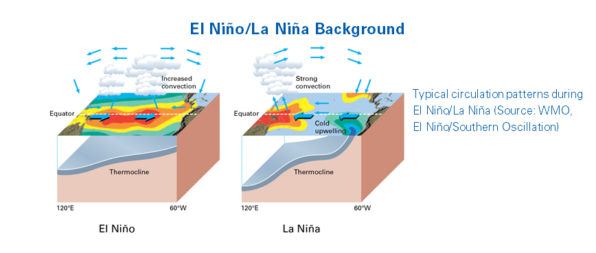
Fig-8: ENSO Concept on how energy flows along the pacific.
To give a good forecast analysis, one needs a basic understanding of ENSO (ElNino Southern Oscillation). The ENSO is caused by thermal Movement of Sea-Surface Temperatures from South America (Peru Coast) to Indonesia and vice-versa. The main aim of this is to Balance the Droughts/Floods.
Elnino-When the Energy is gathered as Sea Surface Temperatures near to Peru coast of South America, there is enormous energy near to their coast. Hence we can see strong cyclones in those region during Elnino period.
Example-Example of which is during 2015, strongest Hurricane Patricia formed close to Mexico coast, that corresponds to Elnino.
Lanina- When the Energy is gathered as Sea Surface Temperatures surrounding the islands of Indonesia, there is enormous energy that drives the weather systems in Indian Ocean. It triggers heavy rainfall and Cyclones/Typhoons to Australia, West Pacific and also Indonesia.
Example-Example of which is during 1899, strongest Cyclone Mahina formed close to Cape york Peninsula of Australia, that corresponds to Lanina.
How ENSO affects the Weather pattern in India? Here are some key lines drawn from the research by Indian Meteorological Association (IMA) from 1901 to 2018. For a Layman to understand there are two assumptions-
- Monsoon Depressions normally formed from the Remnants of West Pacific (WPAC) Typhoons typically gets affected by ENSO. As a part of Annual Cycle corresponding to Elnino/Lanina, the number of Typhoons in WPAC is altered. This affects ISMR by around 39-52 %
- The South West Monsoon winds are weakened/activated by ENSO that indirectly affects the Active/Break Monsoon activity in India.

Fig-9: ENSO versus Rainfall Departure (%) of Mean ISMR in India.
The above plot depicts the correlation of ISMR and Rainfall Departure (%). It suggests that around 47% of ISMR years exactly correlate with ENSO conditions. Remaining times they are independent of ENSO. So out of 100 cases in ENSO we can get 47 outcomes of ISMR in favour of ENSO. So if we take this into consideration and noting Fig-10, we can see slightly above Normal Rainfall in India during the ISMR period from June-September with First-half of August to remain the peak Monsoon month of 2020 pertaining to ENSO Conditions. However exceptions do apply in this where North part of Konkan might see slightly below normal rainfall, as a part of Annual Cycle (As last 3 years been exceptionally great). But it is not conclusive that those areas might remain in Drought/Low rainfall. It will revealed as we move closer to the heart of season.

Fig-10: ENSO Forecast by POAMA, as marked showing a steep decrease in Sea Surface Temperature towards the end of ISMR.
Indian Ocean Dipole (IOD) and MJO action-
When we discuss the weather-related aspects of Monsoon, we can shift our focus on IOD and Madden Julian Oscillation (MJO).
IOD- To represent the Sea surface temperatures in Indian Ocean, the WMO (World Meteorological Organization) maintains some standards. This is the concept of IOD and this represents the changes in Indian Ocean as a part of Annual Cycle.
Example - Cyclone Chapala and Cyclone Megh formed as a part of annual Cyclone season in Arabian sea pertaining to Positive IOD.
IOD can be classified into Two Types:
- Positive IOD - The Western parts of Indian Ocean remains warmer than the eastern and Central parts causing strengthening of easterly winds over India, reducing the strength of Monsoon.
- Negative IOD - The Eastern part of Indian Ocean remains warmer than the Western parts causing the strengthening of Westerly winds over India, enhancing the strength of Monsoon.

Fig-11: IOD Forecast by POAMA, as marked showing a minor decrease in Sea Surface Temperature in Indian Ocean towards the end of ISMR.
Fig-11 shows that IOD remains in Negative phase most of the time, but we can notice it as More negative during August, giving India some upper hand in placing us in Above Normal Category.
Key-Conclusions-
- Overall-Monsoon during ISMR period (June-September) to remain above-Normal in most of the areas (Mainly areas In Monsoon Zone), excess in some areas (Sub-Monsoon areas, Karnataka Coast, North-India including Punjab, Haryana, Himachal Pradesh and Uttarakhand).
- Monsoon might swing between deficit and Normal in areas of South Andhra Pradesh, Tamil Nadu, North-eastern states of India.
- Note that it is almost impossible to say state-wise forecast, but by studying the pattern of ENSO, IOD in-comparison with ISMR we can arrive at some consensus regarding the pattern of Rainfall in India in a situation currently we have.
- The ISMR which Normally peaks in 3rd Week of July, is expected to peak in one among the first two weeks of August.
- The above pattern if it happens will affect the break Monsoon in India that will indirectly affect the rainfall pattern in the regions that are dependent on Break-Monsoon. Analysis of past 83 years suggest that the probability of above statement to happen is around 51% correlation.
Thanks for giving your valuable time reading this blog post. This is based on the interest and thirst to make people understand the weather. If any queries/Questions/mistakes regarding this post, please bring it out to me.
Sai Praneeth B - saipraneeth836@gmail.com
