Where exactly it Rains Heavily in Andhra??
Andhra Pradesh gets Rainfall from Two Monsoons....Firstly the Summer Monsoon(June-September) and the Retreating Monsoon(October-December). During The period of Summer Monsoon, the rainfall will be associated with the Low pressure Monsoon systems forming over Mid-Central Bay of Bengal close to Odisha and North-Andhra coasts. The Monsoon low pressure systems dump flooding rains and causes floods over Krishna and Godavari systems. Sometimes, the local troughs contribute to heavy rainfall. Heavy monsoon corresponds to more and more rainfall...
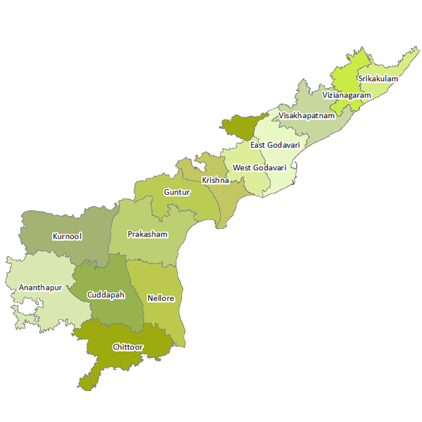
Districts which receives South-West Monsoon Rainfall-
The districts like-
1)Vizianagaram
2)Visakhapatnam
3)Srikakulam
4)Guntur
5)Krishna
6)East-Godavari
7)West Godavari
8)Parts of Prakasham district
9)Kurnool district
10)Anathapuram district
11)Kadapa district
These above districts depend on Summer Monsoon rains and accounts to 60-80% of Annual Rainfall. While the districts like Nellore, Chittoor Districts gets very less Summer Monsoonal rainfall (less than 40% of annual rainfall).
During Summer Monsoon, the heavy rainfall is confined to North coastal districts of Andhra and the South Andhra districts gets less rainfall. Anathapur, Kadapa, Kurnool, Western parts of Chittoor district gets less rainfall.
"North-East Monsoon Role in Making up Rainfall"-
During the Months of October and November, the Monsoon retreats fast and the cyclonic systems develop over South parts of Bay of Bengal. They generally move in North-West Directions and Affect North Tamilnadu-South Andhra Coast. Places like Tirupati, Nellore, Srikalahasthi, Kavali gets heavy to Very heavy rainfall. Some times floods are often over these places during this time. The places like Tirumala gets Extremely heavy rainfall due to Orographic lifting of clouds.
The above Picture Tells a very active North-east Trade wind flow over South Andhra and Tamilnadu coast, resulting in a heavy rainfall.
So which City can be crowned as Andhra's Rainfall King??-
So, to solve this riddle, I took the data of Andhra's rainfall and tried to bring out 5 places, which stand top spots in the competition. The places are-
1)Tirumala
2)Araku
3)Srikalahasthi
4)Tirupati
5)Amalapuram
-- Out of these places, the places like Araku and Amalapuram gets heavy rainfall during Summer Monsoon and the remaining places Tirumala, Tirupati, Srikalahasthi gets heavy rainfall due to Cyclonic systems crossing Bay of Bengal. The places of Coastal will get unless the Bands organize well over the system. Where as, the places provided with Hill-lock systems gets torrential pounding by blocking and raising the clouds. So we can rule out the places like Tirupathi, Srikalahasthi, Amalapuram.
Taking Tirumala and Araku into consideration, we reach a tie breaker....Tirumala average tends to 1477.5mm and araku gets 1098.7mm...But when compared to Tirumala Annual rainfall, the araku rainfall is less. But araku consistently reaching its average inspite of Floods/Drought prevailing over the region of Visakhapatnam district. Hence, i prefer Araku and the surrounding areas are the places in Andhra, where the Heaviest rainfall is concentrated. Whatever it may be, cyclonic or Convectional, rainfall will hit these places, which is not the case in Tirumala. But the place of Tirumala gets extremely heavy rainfall (greater than 25cms) if any Cyclone hits the coast of South-Andhra pradesh.
BY
B.SAI PRANEETH
(WOS)