Heavy Rain On cards To Tamil-Nadu and Kerala
-Says ECMWF
After TN Floods-2015, the state of Tamilnadu bracing for another system (Invest-91B), which is taking shape at South-West Bay of Bengal. Its is associated with high values of Sea Temperatures around 32 degrees, Total Precipitable Water and High Vorticity.
Sea surface Temperature-
INFERENCE:
High Sea surface Temperatures will lead to great amount of Energy which is an essential parameter for the growth of a system. Since May Month is associated with good amounts of Heat, system will contain good rain-bands and moisture flow.
Total Precipitable Water-
INFERENCE:
Precipitable water is the depth of water in a column of the atmosphere, if all the water in that column were precipitated as rain.We can see a High Amounts Of Total Precipitable Water gushing from Equatorial Indian Ocean in the above Map. This entire TPW will pump suitable water vapour into the system now formed and develop good rain bands around the eye-wall. TPW generally gives a well defined structure to the system.
Vorticity-
INFERENCE:
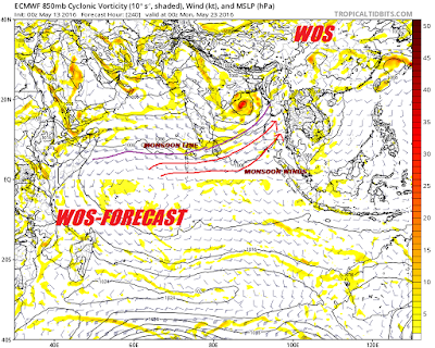
Vorticity is the measure of the Rotating spin around the center of system, which is essential in determining how much strength the system has processed at that time. Now, we have a good vorticity around the system (Invest 91B) , which will lead to good strength and make it moderately windy.
WIND-SHEAR-
INFERENCE:
Wind Shear is the amount of opposition given by wind to the system. Greater the wind shear, weaker the system. Here, the Shear value is less near the east coast of Tamilnadu and Srilanka at present and its likely to decrease further. This will help to keep cyclone to retain its strength all over its journey. Thanks to the Wind Shear.
ECMWF FORECAST REALIZATION-
ECMWF, a leading Weather Forecasting agency tracked the system to be as a minimal cyclone. They also predicted good amounts of rainfall likely over many places of South india, which are closer to the storm Track. At the same a very good news awaits us....Its nothing but "MONSOON ONSET". As the system heads North, The monsoonal Winds will make an entry and tries to fill the "Thermal Void" over North India. Thermal Void is the pressure of Low at the ground level caused due to intense Heat-waves.
CONCLUSION-
Hence i conclude by saying some interesting days on cards to entire South india. I will be tracking ECMWF and GFS models. Whatever it may be, "good rains ahead and it will be a respite to the brewing heat wave but not destructive".
FORECAST BY
B.SAI PRANEETH
(WEATHER OF SOUTH INDIA)


No comments:
Post a Comment