SEVERE CYCLONE TO CROSS THE COAST NEAR COX'S BAZAAR
"MONSOON TO TOUCH KERALA COAST BY JUNE-3rd"
CYCLONE ROANU-
Cyclone Roanu is at 120kms away from gopalpur coast and is likely to intensify further. At present the peak wind reached 92.6kmphr and gusts upto 120.5kmphr. Its likely to recurve completely and approach the coast of Bangladesh close to Cox's Bazaar. Places along the coast of Odisha, West Bengal, Dhaka, Burma likely to get rain. At the same time damage is likely to be moderate over Bangladesh coast, Since the system will slightly tend to weaken near the coast. At the same time the cyclone will pull away the moisture over Andhra and Tamilnadu....letting the intense heat over Gujarath and Maharastra to dip south. There will be a drastic increase in heat over Andhra by 23rd. Many places over Andhra, North-interior Karnataka and Telangana will get 44-46 degrees back.

FORECASTED RAINFALL-

MONSOON ONSET AND PROGRESS??
The much awaiting South-West Monsoon likely to make its progress soon after the landfall of "Cyclone Roanu". Rains will start in Kerala by June 3rd and take a sharp progress thereafter. Cyclones in bay of Bengal make Monsoon onset late, by making the Bay of Bengal Branch Much stronger. According to GFS, the monsoon is likely to touch Kerala shores by june 2nd.
LATEST MONSOON STATUS-

IMD(Indian Meterological Department) issued a heavy rainfall warning to Nicobar islands on the event of Monsoon onsetting. Heavy rain likely to continue over Nicobar islands for next 3 days..then it will shift to Andaman islands.
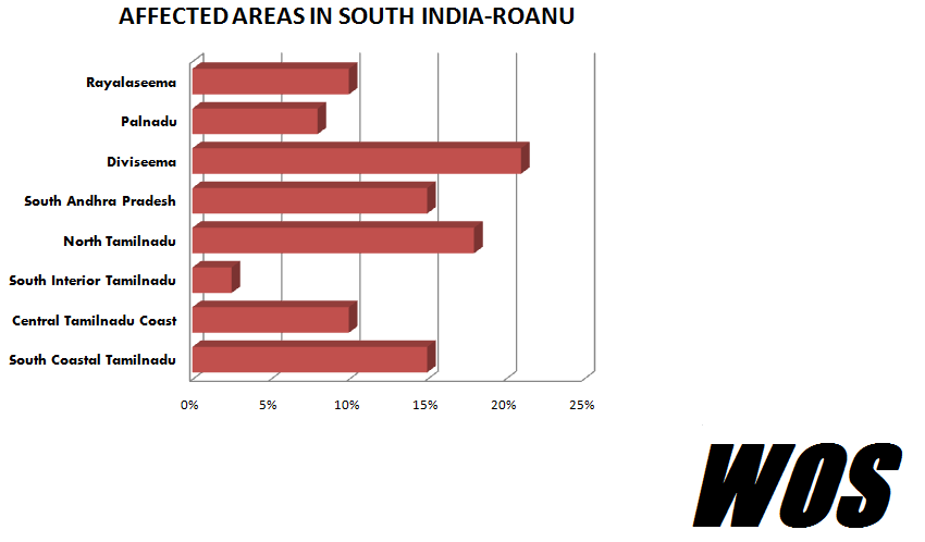
Cyclone-Roanu Performance Over Andhra Pradesh-
The cyclonic storm Roanu, which moved close to Andhra Pradesh, Triggered a heavy dumping deluge with highest touching 35cms of rainfall over Sricity and 24 cms over Tada. Advance to say, It triggered over 29cms over Amalapuram and Avanigadda got 17cms. Tirupathi, which is 76kms away from coast, got 16.1cms overall from this system. Vishakapatnam received a staggering rainfall of 22cms.
ROANU DATA-


Note-
Also, it is said that the Deep-Sea areas got a bulk rainfall ranging from 650-800mm's with coastal areas getting less than 35cms. Interior areas got negligible rainfall, with Tirupathi being an exceptional case. Madanapalle, Hyderabad, Bangalore got some Isolated Thundershowers, which resulted in a relief from burning heat. Still there is a deficit in interior areas. Pre-Monsoonal Rainfall will resume after 28th May over interiors, with a good rain showers to Bangalore. These showers are temporally being halted by Cyclone Roanu.
BY
B.SAI PRANEETH
(WOS)